Winchelsea is a small hilltop town between the High Weald and Romney Marsh, and it earns an afternoon because it is a fragment of something much bigger. Edward I granted a charter in 1281 for a planned town on a grid of 802 building plots, and it was never filled: by 1575 only 60 houses were still inhabited. What you walk is the surviving corner of that plan, on a hill above empty marsh.
The straight-line distance from Hastings is 11.7 km; the town seven miles (eleven kilometres) north east of Hastings and two miles (three kilometres) south west of Rye, which makes it a stop on the way to or from Rye rather than a day in itself.
There is no seafront and no visitor complex: three of the four medieval gates, a part-ruined church with 20th-century glass and Spike Milligan’s grave, a museum above the old gaol, and Camber Castle out on the marsh.
The town was laid out over a hamlet and manor called Iham. Some 13th and 14th-century fortification survives at the Strand Gate and at the Pipewell or Ferry Gate. The scale of the plan is best read at the New Gate, over half a mile outside the present town: the streets never grew out to reach it.
Winchelsea also holds the largest collection of medieval wine cellars in the country, with the possible exception of Norwich and Southampton, and they may still be visited. How access works is not recorded, so ask in the town.
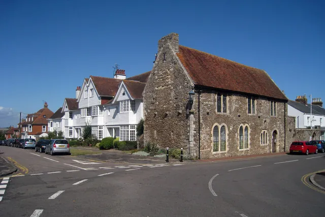
Across from the churchyard is the Court Hall, its lower floor once the gaol and its first floor now Winchelsea Court Hall Museum, 4.8 from 13 Google reviews and so too small a sample to weigh, holding relics of the Corporation and a model of the town as planned. Nearby is the town well, dug in 1851 to save water being carried up the hill and thought to be 80 feet deep.
Work began almost immediately after the flood of 1287. Only the chancel and chapels remain in use; the transepts are in ruins and nothing of the nave is to be seen. By the early 19th century it was “almost unfit for public worship”; it was restored in 1850.
The glass is the reason to go inside. The windows are by Douglas Strachan, a memorial to the town’s dead of the First World War; those in the south aisle, on Land, Air and Fire, and Sea, are described as some of the finest stained glass of the twentieth century in Britain. One commemorates the crew of the Rye lifeboat Mary Stanford, lost in a storm in 1928.
Most come for a grave rather than the glass: Spike Milligan lived near Winchelsea and is buried in the churchyard. The church holds 4.8 from 115 Google reviews, and a visitor in July 2026 wrote, “We went to see the grave of Spike Milligan, which we did, but was bowled over by the inside of the church, beautiful.”
The disused Mary Stanford Lifeboat House, 4.3 from 154 reviews, is listed among the places here as well, reached on foot through nature reserve and coast; there is an information board, and nothing to go into.
Camber Castle was built by Henry VIII in the early 16th century, halfway between Winchelsea and Rye, to guard the approach to the Camber, the anchorage that made the old town rich.
It has 4.2 from 342 Google reviews, the lowest score of the places here, and the reviews explain the gap: the walk is the visit, and the castle is shut. A visitor in June 2026 wrote, “Nice walk to the castle and it’s quite an impressive laid out structure. Shame you can’t go in and walk around.” Another that month thought the closure deliberate — “I believe they open the castle once per year to protect it from further decay” — though that is a visitor’s understanding, not confirmed. Expect sheep on the path.
Further out, Winchelsea Beach takes the town’s name; in the town itself, The Ship Winchelsea holds 4.4 from 254 reviews, praised for its garden and for welcoming dogs.
The present town is the second Winchelsea. The first sat on a shingle bank at the confluence of the Brede, Rother and Tillingham estuaries; the Pipe Roll of 1204 ranks it tenth among English ports, and in the 1260s it may have held over 700 houses and 50 inns and taverns. Storms broke it from the 1230s, the shingle barrier failed for good around 1250, and three storms in 1287 and 1288 destroyed it entirely.
The replacement flourished for about forty years on wool, then on wine, standing second in southeast England for wine imports in 1328. The Black Death and French raids followed: a force sacked and burnt the town in 1360, and by 1366 nearly half the plots were “waste, burnt, and uninhabited”. Then the harbour silted while Channel shipping moved to vessels over 200 tons it could not take. Four ships and 15 sailors were counted in 1524; by 1561, reportedly none of any kind.
The oddity that outlived the trade is the government: the mayor is chosen each year from the corporation’s freemen rather than elected, a relic of the days when the town returned two MPs on about a dozen voters. It lost its civil and judicial powers in 1886 and survives as a charity maintaining the monuments and the museum.
There is a station, but it is not in the town: Winchelsea railway station sits three-quarters of a mile (1.2 kilometres) north, down in the Brede valley, on the Marshlink line between Ashford International and Hastings, and the hourly Ashford service that reaches Hastings in 40 minutes calls there. The town is on a hill and the station is not, so arriving by train means the climb the 1851 well was dug to spare people.
By bus, Stagecoach run a service from Hastings to Rye via Winchelsea; no route number is recorded, so check the timetable.
By road, the A259 from Hastings to Folkestone runs around the edge of the town rather than through it. The Royal Military Canal, built early in the 19th century against an anticipated Napoleonic invasion, passes the eastern side and joins the River Brede.
The village and what is around it, at walking scale.
Open any of them in Google Maps for directions and current opening.
Want live prices and dates? GetYourGuide's booking widget shows them, and sets their cookies in your browser when it loads.
Background on Winchelsea draws on its Wikipedia article, text there being available under CC BY-SA 4.0.